
Mynd:Parishes of Montserrat.svg

Stærð þessarar PNG forskoðunar á SVG skránni: 264 × 401 mynddílar. Aðrar upplausnir: 158 × 240 mynddílar | 316 × 480 mynddílar | 505 × 768 mynddílar | 674 × 1.024 mynddílar | 1.348 × 2.048 mynddílar.
Upphafleg skrá (SVG-skrá, að nafni til 264 × 401 mynddílar, skráarstærð: 7 KB)
Lýsing
| Lýsing |
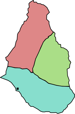
English: A map of the three parishes of the island of Montserrat. Saint Peter is shown in pale red, Saint Georges in green and Saint Anthony in blue. The black square marks Plymouth, the island's capital. Based on http://www.statoids.com/mms.html, however, map data is not detailed enough to have copyright implications. |
| Dagsetning | |
| Uppruni | eigin skrá |
| Höfundarréttarhafi | Jarry1250 |
| Aðrar útgáfur | Derivative works of this file: Montserrat location map.svg |
| SVG genesis |
Leyfisupplýsingar:
| I, the copyright holder of this work, release this work into the public domain. This applies worldwide. In some countries this may not be legally possible; if so: I grant anyone the right to use this work for any purpose, without any conditions, unless such conditions are required by law. |
Breytingaskrá skjals
Smelltu á dagsetningu eða tímasetningu til að sjá hvernig hún leit þá út.
| Dagsetning/Tími | Smámynd | Víddir | Notandi | Athugasemd | |
|---|---|---|---|---|---|
| núverandi | 26. október 2009 kl. 19:42 | | 264 × 401 (7 KB) | Jarry1250 | {{Information |Description={{en|1=A map of the three parishes of the island of w:Montserrat. Saint Peter is shown in pale red, Saint Georges in green and Saint Anthony in blue. The black square marks Plymouth, the island's |
Skráartenglar
Eftirfarandi síða notar þessa skrá:
Altæk notkun skráar
Eftirfarandi wikar nota einnig þessa skrá:
- Notkun á ar.wikipedia.org
- Notkun á ba.wikipedia.org
- Notkun á de.wikipedia.org
- Notkun á en.wikipedia.org
- Notkun á es.wikipedia.org
- Notkun á fr.wikipedia.org
- Notkun á id.wikipedia.org
- Notkun á ja.wikipedia.org
- Notkun á kk.wikipedia.org
- Notkun á lt.wikipedia.org
- Notkun á ml.wikipedia.org
- Notkun á mt.wikipedia.org
- Notkun á nl.wikipedia.org
- Notkun á ru.wikipedia.org
- Notkun á uk.wikipedia.org
- Notkun á vi.wikipedia.org
- Notkun á zh.wikipedia.org