
Mynd:Sevastopol, Ukraine.jpg

Upphafleg skrá (1.080 × 1.440 mynddílar, skráarstærð: 455 KB, MIME-gerð: image/jpeg)
Lýsing
| Lýsing |
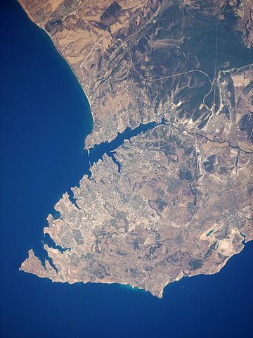
English: This satellite image highlights the jagged coastline of the southern Crimean Peninsula and the various docking areas of Sevastopol. The urban area is light grey, and it is bounded to the north and west by the Black Sea, to the south by vegetated (light green) and fallow (tan) agricultural fields, and to the east by the city of Inkerman and vegetated uplands (deep green). The city of Balaklava, to the south, houses another relic of the Cold War—an underground Soviet submarine base that is now open to the public as a monument. The Chernaya River issues into the Black Sea near Inkerman, flowing into the Sevastopol Inlet to the west.
|
||||||||||||||||||||||||||||||||||||||||||||||||||||||
| Dagsetning | |||||||||||||||||||||||||||||||||||||||||||||||||||||||
| Uppruni | NASA Earth Observatory | ||||||||||||||||||||||||||||||||||||||||||||||||||||||
| Höfundarréttarhafi | This image was taken by the Nasa Expedition 20 crew. | ||||||||||||||||||||||||||||||||||||||||||||||||||||||
Image acquired with a Nikon D3 digital camera fitted with a 400 mm lens, and is provided by the ISS Crew Earth Observations experiment and Image Science & Analysis Laboratory, Johnson Space Centre. Instrument: ISS - Digital Camera.
Leyfisupplýsingar:
| This file is in the public domain in the United States because it was solely created by NASA. NASA copyright policy states that "NASA material is not protected by copyright unless noted". (See Template:PD-USGov, NASA copyright policy page or JPL Image Use Policy.) | ||
 |
Warnings:
|
| Annotations | This image is annotated: View the annotations at Commons |
Breytingaskrá skjals
Smelltu á dagsetningu eða tímasetningu til að sjá hvernig hún leit þá út.
| Dagsetning/Tími | Smámynd | Víddir | Notandi | Athugasemd | |
|---|---|---|---|---|---|
| núverandi | 20. janúar 2015 kl. 11:44 | | 1.080 × 1.440 (455 KB) | Anonimski | Rotated to proper map orientation |
| 24. ágúst 2009 kl. 09:27 |  | 1.440 × 1.080 (532 KB) | Originalwana | {{Information |Description={{en|1=This astronaut photograph highlights the jagged coastline of the southern Crimean Peninsula and the various docking areas of Sevastopol. The urban area is light grey, and it is bounded to the north and west by the Black S |
Skráartenglar
Eftirfarandi síða notar þessa skrá:
Altæk notkun skráar
Eftirfarandi wikar nota einnig þessa skrá:
- Notkun á af.wikipedia.org
- Notkun á ast.wikipedia.org
- Notkun á azb.wikipedia.org
- Notkun á az.wikipedia.org
- Notkun á bn.wikipedia.org
- Notkun á ca.wikipedia.org
- Notkun á de.wikipedia.org
- Notkun á de.wikivoyage.org
- Notkun á en.wikipedia.org
- Notkun á es.wikipedia.org
- Notkun á fa.wikipedia.org
- Notkun á it.wikipedia.org
- Notkun á mn.wikipedia.org
- Notkun á pl.wikipedia.org
- Notkun á pl.wiktionary.org
- Notkun á ru.wikipedia.org
- Notkun á uk.wikipedia.org
- Notkun á uk.wikivoyage.org
- Notkun á www.wikidata.org
- Notkun á zh.wikipedia.org